In a dramatic turn of events on Wednesday, May 20, 2026, heavy thunderstorms unleashed sudden flash flooding across downtown Atlanta, transforming major roadways into rivers and stranding motorists during the evening commute. The most severe impacts centered on the I-75/I-85 Downtown Connector, where rapid accumulation of water forced the shutdown of all northbound lanes.
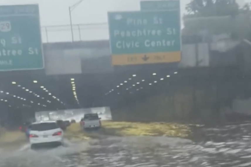
Rapid Onset and Major DisruptionsSlow-moving thunderstorms dumped intense rainfall—reports indicate 2 to 3 inches falling in as little as one hour in some spots—overwhelming drainage systems in the urban core. Flooding was particularly acute near key exits including Baker Street, Freedom Parkway, Peachtree Street, and Pine Street.
I-75/I-85 Connector Shut Down Amid Atlanta Flooding, Torrential Rains
Georgia Department of Transportation (GDOT) cameras captured vehicles navigating waist-deep water, with multiple reports of cars stalled and at least one driver rescued from atop their vehicle near Baker Street.
fox5atlanta.comThe National Weather Service (NWS) in Peachtree City issued and later upgraded flash flood warnings for Fulton and DeKalb counties, including a “Considerable” threat level. Warnings highlighted dangers along the connector and surrounding areas like Druid Hills and Emory. Northbound lanes of the connector were fully closed at points, causing widespread traffic backups that rippled onto I-20 and surface streets. Some lanes began reopening as waters receded later in the evening, but delays persisted into the night.
x.comSocial media and local news outlets filled with videos and photos showing submerged roads, stranded vehicles, and emergency responses. Commuters described chaotic scenes as heavy downpours struck around mid-to-late afternoon, catching many off guard during rush hour.
@911NewsBreaksCauses and ContextMeteorologists attributed the flooding to a combination of slow-moving thunderstorms with high moisture content, typical of patterns that can produce localized “training” rains where storms repeatedly affect the same areas. Atlanta’s urban infrastructure, with its mix of impervious surfaces and older drainage in some downtown sections, exacerbates such events, turning even moderate-to-heavy rain into flash flood risks.
No widespread reports of major structural damage or injuries emerged immediately, but officials urged residents to avoid flooded areas and stay informed via local alerts. The event echoes past flash flooding incidents in the city, underscoring ongoing vulnerabilities in the metro area’s transportation network.
Ongoing Situation and Advice
As of late Wednesday evening, flash flood warnings remained in effect in parts of the metro area until around 11:15 PM EDT. Additional rainfall was possible, keeping risks elevated for low-lying spots.
Authorities recommended:
- Avoiding travel through flooded roadways—”Turn Around, Don’t Drown.”
- Checking GDOT and local traffic apps for real-time updates.
- Heeding NWS alerts for Fulton, DeKalb, and surrounding counties.
This sudden deluge served as a reminder of the power of spring and early summer thunderstorms in the Southeast. Residents and commuters are advised to monitor forecasts closely as unstable weather patterns continue. Stay safe, Atlanta—drive cautiously and stay dry. Updates will continue as cleanup and recovery efforts proceed.